Projects, Mardi Gras - Research Plan
Research Plan
Research at the Mardi Gras Shipwreck was guided by a number of specific questions:
- What is the identity, age, national affiliation, and function of the vessel?
- What can be learned about shipboard life at the time the vessel was in use?
- Where was the vessel constructed? Was it constructed for a different purpose than its final use?
- Why was the ship armed? Was it defensive or offensive?
- What caused the vessel to be lost? Why was it lost in this particular spot? Does it relate to other losses in the area?
- Does the vessel relate to any specific historical event or person?
- How does the fact that the vessel lies in 1,220 m (4,000 ft) of water affect artifact preservation?
- How do site formation processes differ in deepwater environments?
- What was the vessel’s place within prevailing global economics and geo-political systems at the time of its loss?
Field Methods
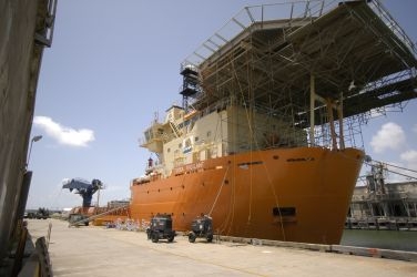
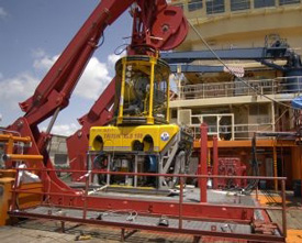
Triton XLS-17 ROV
Sperre 7500
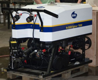
The Sub-fighter 7500 ROV is a Sperre AS vehicle constructed specifically for the Mardi Gras Project and was the property of the Department of Oceanography at Texas A&M University. While it had a limited payload capacity of 11-17 pounds (5-8 kg), it was equipped with two cameras (one high-resolution), as well as four 250-watt lights. The primary purpose of this vehicle was to document the work of the Triton XLS-17. The 7500 was also equipped with a five-function manipulator and could pick up small artifacts in the event the Triton was temporarily non-operational.
High-Resolution Digital Video and Still Cameras and High-Intensity Lights
Unlike archaeological projects on land, every single task performed on the seabed during the Mardi Gras Shipwreck Data Recovery Project was documented on video. For the success of the project, it was important to document the artifacts on the seabed with as much resolution as possible. Once removed from the seabed, the only information allowing archaeologists to match the artifact to its number (along with the lifting basket allocation information) was be the visual file. For this reason, visual documentation was of crucial importance and was provided by high-resolution digital still cameras with high-intensity lights.
Special Tooling for Typical Artifact Retrieval and Excavation
Special Tools used on the Mardi Gras Shipwreck excavation included:
- Feedback manipulator
- Standard manipulator
- Excavation dredge and screening system
- Scaling lasers
- Suction Pickers to recover small artifacts
- Scoops to recover small artifacts
Special Tooling for Large Artifact Retrieval
Positioning
One of the most critical aspects of archaeology is the precise location of artifacts in the context of the site. By carefully recording every artifact’s position on the seafloor, we could see patterns emerge will defined specific use areas, such as the captain’s quarters or the common seaman’s berths. One of the greatest challenges of working in 4,000 feet of water was mapping the artifacts on the seafloor and positioning the ROV. UTEC Survey Inc. provided survey support, which included acoustic positioning and geo-referenced video support. Basic positioning of the ROVs was provided by employing a Kongberg Ultra-Short Base-Line (USBL) system, which had a typical accuracy of 0.5 percent of water depth. In order to minimize the USBL error as a function of the water depth, UTEC deployed a seabed transponder known as “relative USBL.” The system was based on navigation software that examines the location derived from normal USBL observation and error correction provided by the fixed transponder on the seabed, thus maintaining system and environmental errors to a minimum on the remote transponder attached to the ROV. In addition, Kongsberg provided a system known as the High Accuracy Inertial Navigation System, or HAINS. The result was a more stable and precise reading of the USBL signal, which increased the accuracy of all measurements taken.
Pre-Excavation Remote Sensing
Prior to removing artifacts, non-destructive remote-sensing instruments like sonars, multi-beam fathometers, and subbottom profilers helped us to learn as much as possible about the site. This helped us plan the excavation.
Multi-Beam Bathymetry
Subbottom Profiling
Prior to removal of artifacts or overburden from the site, a survey was run using an Omni Technologies, Inc. (OTI) parametric subbottom profiler mounted to the Triton ROV. Running at a 15-kHz bandwidth centered at a 30-kHz difference frequency, up to 9 m (29.5 ft) of penetration in silty sands was achieved. The PFRS system comes with an acquisition and playback software package. Acquisition can be performed entirely autonomously or in real-time with user control. The playback software provides a profile screen with controls similar to a VCR. A rich set of functions provides the ability to review a survey, annotate and perform screen captures. The narrow 3° beam allowed the imaging of buried features, hull structure, and large artifacts, which aided in planning the investigation.
Mapping
Mapping the site was done by capturing a minimum of four high-resolution, orthogonally-corrected photo-mosaics over the course of the project. To accomplish this, the Triton ROV was deployed with scanning sonar, high-resolution video cameras, and digital still cameras. Digital still and video imagery was acquired at an ROV flight altitude of 4 m (13 ft), provided a swath coverage of 4.5 m (14.7 ft). In order to achieve coverage with a 60 percent overlap, transect lines spaced approximately 3 m (10 ft) apart were flown. A coarse mosaic was created the same day the mosaic survey took place. After finishing the coarse mosaic and loading it in Site Recorder 4 as a base layer, the process achieved a better resolution image. The first step for obtaining a high-quality mosaic was to remove camera distortion and parallax.
Artifact Collection
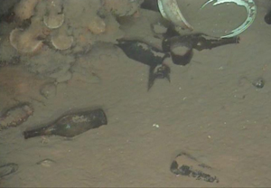
- Wine bottles
- Rum bottles
- Square condiment or medicine bottle
- Ceramics (likely creamware)
- Bowls
- Plates
- Cups
- Pôt de creme
- Double-handed creamer or sugar bowl
- Teapot
- Pitcher
- Stoneware storage jar
- Metal (pewter or silver) shaker
- Navigational instruments
- Telescope
- Octant
- Compass
- Hourglasses
- Ship's stove, iron
- Cannon, cast iron in carraige
- Wooden chest containing the following:
- Pistols, flintlock
- Muskets
- Sword
- Other edged weapons
- Stacked wooden crates, contents unknown
- Anchor
Site Recorder 4, developed by 3H Consulting, Ltd., was selected as the main software system for recording, registering, and cataloguing artifacts from fieldwork through the conservation process. The software is a fully-integrated GIS designed by archaeologists for use in maritime archaeology. Site Recorder 4 can manage thousands of artifacts, drawings, photographs, video clips, documents, and geophysical data files that can be linked together for analysis and interpretation. Artifacts were cataloged by their functional class and material of composition, photographed before and after recovery, plotted on the site map and assigned a unique artifact record number.
Soil Samples
A minimum of six sediment samples were collected with push cores (1 m x 7 cm diameter [3.28 ft x 2.75 in]) at various points on and near the shipwreck for the purpose of determining sediment type and basic properties. Immediate field analysis of select sediment samples helped determine the amount of slumping that could be anticipated to occur during the removal of artifacts.
Wood Samples
Wood samples were collected from in situ elements of the shipwreck. Recovered artifacts also were sampled in the conservation laboratory to assist with identification. Hull components sampled in situ were selected to minimize adverse impact to the site. Consideration was given to their position, location, and archaeological context. An attempt was made to collect wood samples from major elements of the hull where the use of differing types of woods was anticipated, such as the stem or stern posts, keel, keelson, frames, planking, wales, or treenails.
Excavation
Excavation was limited to clearing areas around the large artifacts and features to aid in their recovery, to more fully expose elements of the hull already partly exposed (most of the port side) for documentation, and to investigate possible features or artifacts revealed by the subbottom profiler. One goal of this work was to determine the position of mast steps and other features that might lead to an estimation of the size and rigging of the vessel. Excavation was carried out using a small venturi suction dredge attached to a pump mounted on the Triton ROV. Excavated material was exhausted through a 0.6 cm (¼ inch) mesh screen mounted on the aft end of the ROV to catch small finds inadvertently suctioned off the seafloor. The greatest challenge in conducting excavation on the site is the fact that there was very little to no current to carry off the fine silt injected into the water column. This resulted in an immediate loss of visibility that impaired any recovery, mapping, or photography effort for hours until the silt settled. As a result, excavation was carefully planned and executed according to prevailing conditions at the time.
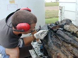
Conservation of Artifacts
Curation of Artifacts
Once conserved and properly labeled, artifacts will be delivered to the Division of Archaeology of the Louisiana Department of Culture, Recreation, and Tourism for permanent curation and future study.
