Projects, STAMP
The Shipwreck Tagging Archaeological Management Program (STAMP) is a public engagement program focused on documenting and monitoring shipwreck sites and disarticulated shipwreck timbers along Florida’s coasts. Anyone can participate in the program! Click below for more information and to discover local volunteer opportunities at training workshops held throughout the state.
Why monitor shipwreck timbers?
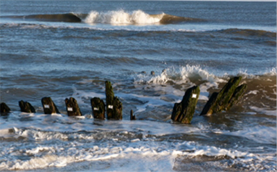
Monitoring archaeological sites is vitally important to understanding how sites change over time. Particularly coastal and near-shore submerged sites may be affected by erosion, wave action, storms, tides, and currents, as well as human factors like vandalism and looting, construction, dredging, and development.
Occasionally, wooden timbers from historic shipwrecks can become entirely detached, or disarticulated, from the hull. These timbers may wash ashore, become covered or uncovered by sand, wash out to sea again, and travel enormous distances pushed by waves and wind. If we can track these timbers, we can learn about site formation and change, and may even discover wrecks that have not yet been recorded.
How can you help?
Through STAMP, we are encouraging the public to work as citizen scientists! Efforts by STAMP volunteers will allow archaeologists to collect data to plot how coastal shipwreck sites physically change and how disarticulated timbers may move over time. By monitoring these dynamic sites, we hope to learn how to more effectively manage these delicate and finite resources.
STAMP was modeled on a shipwreck tagging program that began in the summer of 2013 as a project of the Fish and Wildlife Service at the Chincoteague National Wildlife Refuge. Data received from the program illustrated the dynamic nature of coastlines and the resulting effects on coastal shipwreck sites.
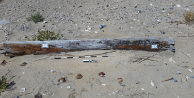
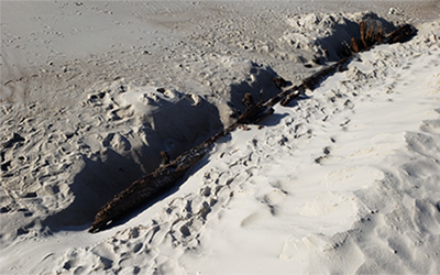
The picture above is of tagged timber number 67. This timber was first tagged in September of 2014 and is approximately 3 meters long. A year later (2015), timber 67 moved at least 40 meters. During the winter of 2015, however, Chincoteague National Wildlife Refuge was ravaged with numerous harsh storms. A submission in January 2016 indicated that timber 67 was in Corolla, North Carolina. As pictured below, the shortest distance the timber could have traveled from its 2015 location on Chincoteague to the GPS coordinates received from the January 2016 submission (just outside of Corolla) was 106 miles!
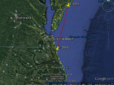
Since it is unlikely that timber 67 traveled in a straight line to Corolla, North Carolina, it may have traveled even farther than 106 miles. Today, the timber has been reported by the public 15 miles south of Corolla in Duck, North Carolina. Timber 67 is still on the move!
While many people think that disarticulated shipwreck timbers found on shorelines and beaches must be near a ship's original wrecking place, timber 67 proved that one shipwreck timber moved over 100 miles in just two years. This data helps archaeologists to consider how far shipwreck timbers could move in 50, 100, or even 200 years!
For more than thirty-five years, the Department of Historic Resources is the Virginia Commonwealth’s official historic preservation agency, and its director is designated as the State Historic Preservation Officer (SHPO). Department staff administers both federal and state mandated activities. Additionally, the department maintains an open-to-the-public research center with both paper and electronic archives. Virginia DHR curates the Commonwealth’s archaeological collections and makes these collections available to researchers and to the public. Educational programs include Virginia Archaeology Month, Teaching with Historic Places, an Archaeology Resource Kit, tours of the department’s curation and conservation center, and other changing programs for adults, children, and educators. The department also produces several reference publications, most available for downloading from its website.
The National Park Service Submerged Resources Center has been a nationally and internationally recognized leader in operational and scientific diving as well as the location, documentation, interpretation, and preservation of underwater resources--primarily cultural resources. The center embraces an interdisciplinary approach to resource management issues and works actively across disciplines to provide science-based recommendations to parks and partners in line with the preservation mandate of the United States National Park Service.
The mission of the Submerged Resources Center is to provide direct project support to superintendents and partners responsible for the stewardship of submerged resources, and to enhance and facilitate public appreciation, access, understanding, and preservation of these resources.
The Maryland Historical Trust is an agency of Maryland Department of Planning and serves as the Maryland State Historic Preservation Office. The agency serves to assist in research, conservation, and education, about Maryland's historical and cultural heritage.
The Maryland Maritime Archaeology Program (MMAP) was created in 1988 to manage significant historic shipwreck remains as well as the State's other submerged cultural resources, including prehistoric sites, historic structures such as buildings, bridges, and wharf remains. MMAP carries out survey and documentation of sites, regulates and manages heritage resources in, partially in, or submerged beneath State waters. This includes implementing regulations, reviewing applications for research, recovery, or construction projects, as well as assessing and evaluating sites for National Register eligibility. MMAP also assists governmental agencies and their program clients to meet their statutory historic preservation responsibilities through the project review and compliance process, and undertakes cooperative endeavors with numerous agencies, groups, and organizations at local, state, and federal levels to promote wise heritage resource management as well as public education and outreach.

Over land and under water, SEARCH is an archaeology firm that deploys the full spectrum of cultural heritage services worldwide. SEARCH2O, its maritime program, is at the forefront of historic shipwreck and submerged pre-contact archaeology, paleolandscape reconstruction, and deep-water archaeology. SEARCH's staff are cultural resource industry leaders, pioneers, and subject matter experts across 44 markets, regions, and research sectors. Since 1993, SEARCH has completed more than 4,000 commercial and government projects in 47 states, 6 US territories, and 32 countries spanning six continents and four oceans. By integrating science, technology, and creativity, SEARCH harnesses the power of the past to advance the projects, places, and people it serves.
